The Way We Were: Important 1846 Folding Pocket Map of Texas, Oregon, and California by S. Augustus Mitchell

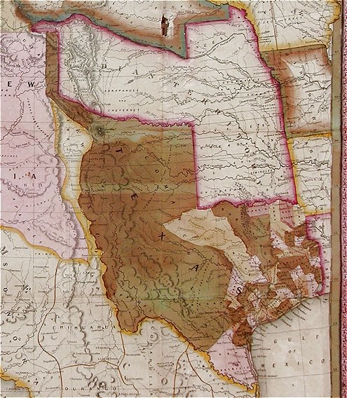
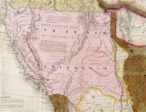
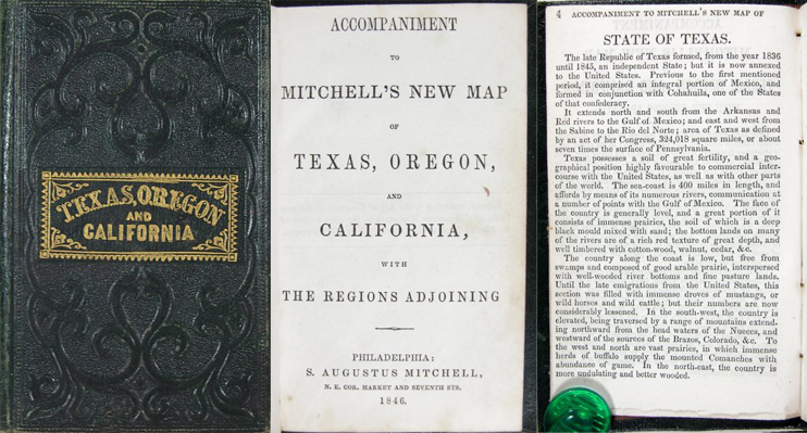
Above is an image of the historically important, separately bound, 1846 Folding Pocket Map of Texas, Oregon & California by S. Augustus Mitchell. This important map of the newly annexed State of Texas and the soon to be acquired Territories of the Western United States, is fully titled in the cartouche: “A New Map of Texas, Oregon and California With the Regions Adjoining Compiled From the Most recent Authorities Philadelphia, 1846. Published by S. Augustus Mitchell.” It is marked at the lower left with the passage, “Entered According to Act of Congress in the Year 1845 by H.N. Burroughs in the Clerks Office of the District Court of the Eastern District of Pennsylvania.” The map measures approximately 21” by 22 1/2”, and was contained in a leather bound “Pocket Guide” titled “Accompaniment to Mitchell’s New Map of Texas, Oregon and California with the Regions Adjoining. Philadelphia, 1846. Published by S. Augustus Mitchell.”

Pictured here is the 1st edition of this important map of the Western United States, which, with its accompanying Emigrant’s Guide, has been widely and frequently praised as the most accurate and current information then available in separate cartographic form for the regions shown. According to the accompanying Volume, “The chief authorities from which the map is compiled, are the Congressional Map of Texas, 1844, Kennedy’s Map of Texas by Arrowsmith, Mitchell’s Map of Texas, Ward’s Map of Mexico, Frémont’s Map of his explorations in Oregon, California, &c., 1842, 1843, 1844, Map of Lewis and Clarke’s tour, Major Long’s tour to the Rocky Mountains, Nicollet and Frémont’s exploration of the country between the Mississippi and Missouri, the Congressional Map of the Indian territory, and Mitchell’s Map of the United States.”

The map shows in detail the western portion of the U.S. to the Pacific, with the Indian Territory, Missouri Territory, Iowa, and portions of the states of Missouri, Arkansas, Louisiana, and Wisconsin, as well as northern Mexico and part of British Columbia, illustrating in detail the trans-Mississippi region at a time when war was imminent with Mexico.

Great attention has been given to Texas, and the map includes a VERY early depiction of Texas as a state of the Union, complete with all its extravagant territorial claims, including a Panhandle that stretches aggressively north to the 42nd parallel and a border on the Rio Grande River. This map has been updated, however, to show Texas divided into counties instead of empresario grants.

For those contemplating the journey West, the Oregon Road and the Santa Fe Trails from Independence, Missouri, are shown, and a table of distances between Westport and Oregon City is printed. Yet, even with these advances, the map also makes clear the vast stretches of Old Mexico and the West that remain unknown and unexplored. Much of California and the rest of the West is portrayed as basically featureless; “California” occupies the entire area of modern-day California, Arizona, Nevada, New Mexico, Utah, and Colorado.

Much of the information the map lacks, is supplied by the accompanying guide, which discusses Texas, Oregon Territory, California, Iowa, Indian Territory, and Missouri Territory, with the majority of the text devoted to the first three. Some of the remarks about Californians are astounding in several respects, even for the time:

“Descended from the old Spaniards, they are unfortunately found to have all their vices, without a proper share of their virtues…. Their amusements are cock-fighting, bull and bear-baiting, and dancing…always accompanied with excessive drinking…. The female portion of the community are ignorant, degraded, and the slaves of their husbands…. The Indians of Upper California are indolent and pusillanimous…they are all extremely filthy in their habits.” (pp. 28-29)

On the other hand, Texas, the success of which Mitchell clearly wishes to promote, is made to sound like an earthly paradise. Oregon, which Mitchell wants the United States to incorporate, is also described favorably at great length. By contrast, the Missouri Territory is only briefly touched upon, in an almost dismissive manner.

If you are interested in learning more about this item, please see our eBay listing.

Posted in 19th Century, American West, Collectibles: Printing, Maps | Tagged , , , , , , , , , , , , | Leave a comment

Comic Icon: Never-Before-Seen 1896 Candy Container Featuring R. F. Outcault’s “The Yellow Kid”

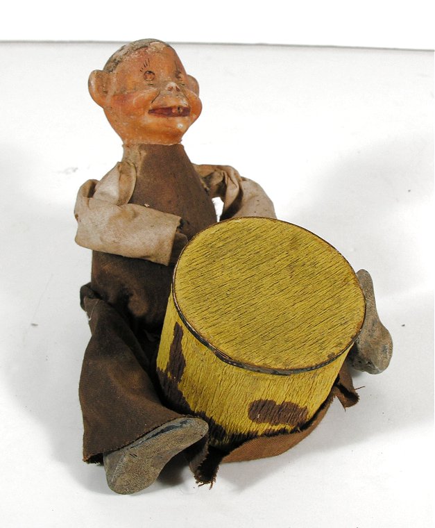
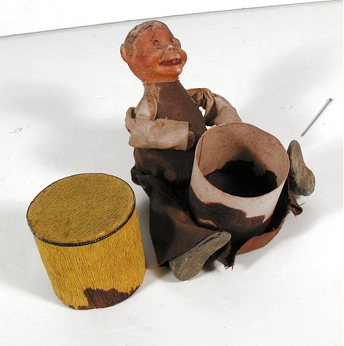
Pictured above is what is believed to be a previously cataloged, circa 1896 Richard OutcaultYellow Kid” Wax Head Full Figure Doll Candy Container (click here for a history of the evolution of the Yellow Kid). Extensive research has been unable to discover another example of this early, newspaper comics character having surfaced, nor any mention of the container in the extensive references pertaining to Yellow Kid Collectibles.

The Yellow Kid was the name of a lead comic strip character that ran from 1895 to 1898 in Joseph Pulitzer’s New York World, and later in William Randolph Hearst’s New York Journal. Created and drawn by Richard F. Outcault in a strip entitled Hogan’s Alley (and later under other names as well), it was one of the first Sunday supplement comic strips in an American newspaper. The Yellow Kid is also famous for its connection to the coining of the term “yellow journalism.”

Mickey Dugan, better known as The Yellow Kid, was a bald, snaggle-toothed boy who wore an over-sized yellow nightshirt, and hung around in a slum alley typical of certain areas of squalor that existed in turn of the 19th to 20th century in New York City. Hogan’s Alley was filled with equally odd characters, mostly other children. With a goofy grin, the Kid habitually spoke in a ragged, peculiar ghetto slang, which was printed on his shirt, a device meant to lampoon advertising billboards.

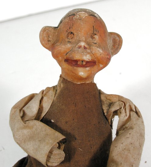
This apparently previously unknown Yellow Kid Candy Container features the Yellow Kid doll seated with a large drum between his legs. The delicate, thin paperboard drum is covered with an even more delicate, yellow crepe paper, and the top and sides of the drum slide off the base revealing the container which held the candy. The Yellow Kid doll/figure features a wax head, wax hands, and some type of papier-mâché composition shoes. His torso is solid and appears to be contiguous with his head. It is also likely made of wax. He wears a stiff, cloth nightshirt or tunic that appears to have originally been off-white in color (though possibly a light yellow), but is now mostly a dark brown. It appears that he may have originally worn a small hat (there is a small hole in his head and a small ring around the hole that appears to be a “shadow” of where a hat may have been.

The candy container measures approximately 4” tall to the top of the seated Yellow Kid’s wax head, and 4” by 4” at the base (measured from the soles of the Kid’s shoes to his upright back and across his widely spread legs). The drum shaped paper container itself measures approx. 2” tall and 2” in diameter across the head of the drum.

Although the candy container is not marked in any way, there is absolutely no doubt that this is the Yellow Kid – besides his trademark, floor length nightshirt/tunic and the fact that he is “beating the drum,” the figure’s wax head distinctly shows the characteristics of Outcault’s comic creation. This includes two large front teeth (the Kid was often called “snaggle-toothed”), very large ears that are perpendicular to his head, and the trademark Yellow Kid “goofy grin.”

While the cloth nightshirt of the Yellow Kid is complete and intact, it has been stained a uniform, dark brown color (all of the nightshirt except the arms and the top of the back), and there are blotches of a similar brown color on the sides of the Drum. It appears to us that the original candy contained in the Drum melted or deteriorated in some way and caused this staining. The pattern of blotches on the sides of the Drum actually give it the “look” of an “animal skin” surface which, in truth, is quite attractive (although not original). The fact that the body of the Yellow Kid’s Nightshirt is quite uniformly stained dark brown and the arms remain light, creates a rather appealing look also (again, however, not original).

While we were able to uncover a number of very rare and highly desirable wax head doll candy containers from the late 19th century, we have found no mention in any of the references, nor any online references, to a Yellow Kid Candy Container such as the one offered here. We believe that it may, in fact, be a previously unknown Yellow Kid item and perhaps the only known example. Any information regarding the rarity and/or manufacturer of this fantastic Yellow Kid Candy Container would be greatly appreciated!!!

If you are interested in learning more about this item, please see our eBay listing.

Posted in 19th Century, Americana, Collectibles: Advertising, Collectibles: Toys | Tagged , , , , , , , , , , , , | Leave a comment

Exciting and Historic Find! Map of Miami, 1849: THE First Known View of a Settlement on the Spot Where the City of Miami Would Flourish!

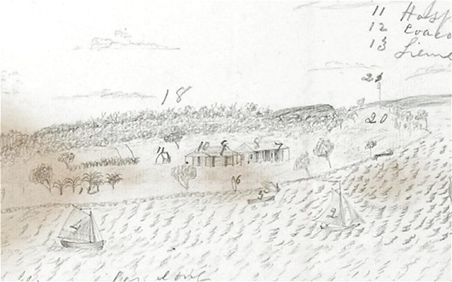
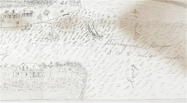
We are proud to be able to announce the discovery of an exceptionally important 1849, hand drawn, bird’s-eye-view of Miami, Florida. In fact, it is the first known view of a settlement on the spot where the City of Miami would eventually flourish!! This drawing, depicted above, was made by a member of Company F of the United States Army’s 2nd Artillery Regiment, which occupied the land at the mouth of the Miami River (then known as Fort Dallas) from October 1849 to December 1850. This was the third and longest occupation of the site of Miami, Florida by U.S. Army troops, and was the first occupation since the site was abandoned in January, 1841.

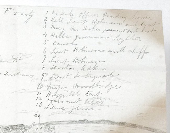
We cannot stress enough the historical importance of this amazing view. It is the first known depiction of the settlement at the mouth of the Miami River, and as such is the first known view of what would become the City of Miami, Florida. The drawing was made by an artillery soldier and sent in a letter to a member of his family that lived in Southern New Hampshire. The artillery soldier not only drew a highly detailed view of all of the buildings that made up the settlement, but he also included a legend that identifies each structure as well as various topographical details. The soldier has even drawn representations of the “recreational” sailboats belonging to various officers of the Regiment.

First, a physical description of the Drawing:

The bird’s-eye-view is drawn in pencil on an unlined sheet that measures approximately 12 ½” by 7 ½”. The view itself occupies the lower half of the sheet, and depicts both the north and south banks of the Miami River at the point where the River empties into Biscayne Bay.

Fort Dallas, located on the north bank, is in actuality a cluster of small, unfortified structures. Each building is numbered and each is identified in the legend which appears in the upper half of the sheet. Included are structures identified as the residences of “Major Woodbridge,” “Dr Adkins,” “Lieut. Robinson,” and “Lieut. De Sagnol” (these are the officers of the 51-man garrison that occupied the site of Miami, Florida in 1849-50). Other structures include those identified as “Hospital Tent,” “Company F Kitchen,” “Stone Building unfinished Company F 2nd Artillery,” “Log houses. Bakehouse, Hospital, Kitchen, etc,” as well as a few other miscellaneous structures. Topographical details include those identified as “Pine Woods,” “Hammock,” Coconut Trees,” “Lime grove.” “Mound supposed to have been made by Indians,” and “Coast survey signal.”

There is a single structure on the south bank of the river, which is identified as “Mr. Duke’s Officer Boarding House,” The artist has drawn 5 boats in the river which are identified as “Kate – Lieut. Robinson’s sail boat,” “Mary – Mr Dukes government sail boat,” “Lieut. Robinson’s small skiff,” “Dallas government Lighter,” and “Canoe.” A pencil notation is written in the Miami River that reads, “Miami River five miles long / connecting everglades and bay.” Another pencil notation is written in the bay that reads “Biscayne Bay / 3 to 8 miles wide / 40 miles long.”

Besides the structures and identified details, the view includes a wonderful assortment of trees and vegetation that gives a real sense of the “look” of the area at the time the drawing was made. In the distance at the right, the profile of the opposite shoreline of Biscayne Bay can be seen. This wonderful drawing has a charming, “folk art” appearance, even though it is very detailed and was meant to be a true illustration of the site and not a work of art.

The View has vertical and horizontal folds as well as areas of light staining that confirm that it was included in a letter sent through the mail. Unfortunately, we do not have the letter sent with it nor the cover it was sent in.

Now the History of the View:

This important drawing came directly from the descendents of the soldier that made the drawing. About 2 years ago, a Southern New Hampshire auction house sold the contents of a local estate. There was an archive of letters written by an ancestor who served as a member of the 2nd Artillery and was stationed at Fort Dallas from October 1849 to December 1850. Shortly before the archive of letters were offered for sale, the family decided to keep the letters and withdrew them from the sale. This map, however, was somehow overlooked, and was purchased as part of a small group of unrelated documents and ephemera.

We have spent the past two years trying to contact the family through the auctioneer in the hopes of identifying the soldier and/or obtaining the letter of transmittal that surely accompanied the drawing. All of our efforts have been thwarted, and we have finally decided to unveil and offer the drawing “as found” with as much historical information as we have been able to find regarding its origins.

We contacted the HistoryMiami Museum – the premier repository of information and artifacts related to the history of Miami, Florida. The curators there were extremely excited about this amazing find. While not willing to state outright that this was most certainly the earliest known view of Miami (the Museum collection includes a map of the area dated 1852 that they are proud to state is the “earliest known depiction of Miami”), they agreed that this drawing was certainly “one of the earliest depictions of a settlement on the site of the City of Miami.”

In our effort to uncover the date and circumstances of the creation of this drawing we did uncover some significant information about the occupation of the site at the mouth of the Miami river in the first half of the 19th century which are summarized here:

The first two occupations of Fort Dallas (at the mouth of the Miami River) were by the Navy, Lieutenant Levin M. Powell having been sent there in 1836 and again in 1838. Operations for these short periods were those of deposit, repairs and rests after duty. Powell prepared the post for the Army in 1838 and US Navy Captain Isaac Mayo opened it again for the military in 1839.

After General Jesup defeated the Seminoles on the Loxahatchee on January 24, 1838, Fort Dallas was occupied in order to assist in rounding up the Indians and preparing them for emigration. Fort Dallas was planned to be used for a barrier to the Seminole advance into south Florida and also as an avenue of entrance by the Army into the Everglades. The first military occupation of the post lasted only from February into April of 1838. The first long occupation of Fort Dallas began in October, 1839 and lasted until January, 1842. Fort Dallas had no permanent structures during this period and was merely a tented camp.

In October, 1849, Fort Dallas was occupied again; this time by a single company (except for the first month) – Company F of the 2nd Artillery. The occupation lasted fifteen months and it was during this period that our soldier drew the view seen here. While we have been unable to identify the artilleryman who drew this wonderful view, we have found an extract of the 1850 census that details the occupants of Fort Dallas. In all, the site was occupied by 52 “persons” – 3 officers and 49 members of Company F. Of the 49 soldiers listed in the census documents 33 of the men were foreign born (25 were Irish, 5 were German, 2 were Scots, and 1 was English). Half of the 14 native-born soldiers were from New York and two were from Southern states (one each from Georgia and North Carolina). This leaves only 5 soldiers who could possibly have been the “artist” who drew the view offered here, and we believe that an examination of the complete census record will likely make it possible to determine who drew the view given that we know the soldier came from the New England states (likely New Hampshire).

While we have already done some significant research into the history and origins of this important piece of Miami / Florida History, the door remains open for further research and we trust the next owner will continue this quest!!!

If you are interested in learning more about this HISTORIC map, please visit our eBay listing.

Posted in 19th Century, Americana, Collectibles: Printing, Maps | Tagged , , , , , , | Leave a comment

Walnutts on Facebook: Do Antiques Have A Place in Social Media?

Walnutts Antiques is now on Facebook! Join the conversation!

When I was creating the Walnutts Facebook page, I was struck by the dichotomy of having a business rooted deeply in the past, and combining it with a technology that is consistently reliant on the future.

And I wondered: What is the place of antiques in social media?

Antiques tell stories of people’s lives. They give us clues into the daily goings-on of someone who lived 100 years before our time. They provide unique insight into historical moments, and give us a sense that there is something larger than just our time. With Facebook, one can argue there is a similar effect; it has the potential to communicate a story to a wider audience, to share similar stories, to exchange ideas. Antiques have a place on Facebook just like any other entity: they are reminders of our historical foundations and how that has contributed to our development, today. I hope our readers will join us on our Facebook page and ask all those questions that have been burning in their minds about antiques and collecting! See you there!

Posted in Admin | Tagged , , | Leave a comment

Walnutts FAQ’s: What is “Rare?”


Q. What do you mean by “rare,” exactly? I notice several of your items are marked as “rare.”

A. First of all, please do remember that the term “rare” is a statement of someone’s opinion. So, with that in mind, it is important to note that what might be relatively common to someone experienced in a particular field of collecting, could be “very rare” to the average person on eBay or to someone who does not have access to antique shows, collector’s auctions, etc. Statements like, “It is rare to find an honest person nowadays” are a matter of opinion, and although there were millions of Steel Pennies made in the 1940′s, anyone under the age of 25 would describe them as “rare.”

There is a factual component as well, based on the number of existing copies, circulation, and historical factors. However, even this can be seen as relative, therefore there is no quantifiable degree of “rarity.”

Posted in FAQ | Tagged , , , , | Leave a comment